Cities across the world are growing faster than ever. Urban planners are in need of population growth, traffic and resource shortages. Cities are moving to find solutions to these and one of the most promising is the Digital Twin for Urban Planning. This technology assists in developing an actual time, information based virtual form of a city that allows planners the ability to test, simulate and streamline decisions prior to their execution in the reality world.
The Digital Twin for Urban Planning transforms the city management process into a dynamic and responsive one with the help of live data, sensors, and artificial intelligence. It assists leaders in creating sustainable spaces, infrastructure enhancement, and resilient urban systems which react smartly to change.
Table of Contents
What Is a Digital Twin for Urban Planning?
A digital twin is a living, breathing digital model of a city or infrastructure system. Unlike traditional static maps or CAD files, a digital twin updates constantly using live data feeds. It mirrors the real city every road, building, and utility system in virtual form.
This enables planners to monitor what’s happening in real-time and forecast what might happen next. For example, if a new flyover is planned, a digital twin can simulate how it will affect traffic, air quality, and nearby neighborhoods. This kind of smart planning reduces risks, saves costs, and creates sustainable outcomes.
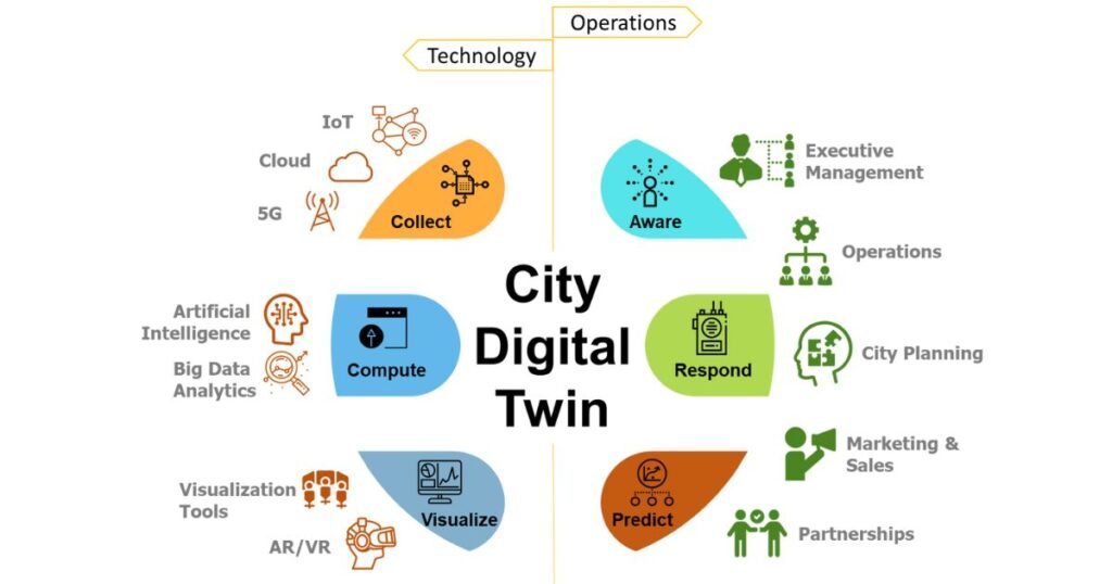
Core Components of a Digital Twin
| Component | Description |
| IoT Sensors | Capture real-time data from traffic, air quality, and weather. |
| GIS Mapping | Displays spatial and topographical data of the city. |
| AI Algorithms | Analyze large data sets and predict urban trends. |
| Cloud Storage | Stores and integrates massive urban data sources. |
| 3D & 4D Modeling | Visualizes current and future city conditions. |
All these factors will be integrated to make sure that a Digital Twin of Urban Planning provides a real-time image of the way the city is functioning, and how it can be improved.
How Digital Twin for Urban Planning Works?
It operates through a series of structured steps. Each stage brings real-world and digital data closer, creating an intelligent model that evolves continuously.
Step 1: Data Integration and Collection
The first step is gathering data. This will contain data on sensors, traffic networks, energy networks and official records. These points are the basis of the twin and they are put in a single platform.
Step 2: 3D and 4D Visualization
When the data have been brought together, the city can be displayed graphically. There is the 3D model of structures and streets and the 4D layer adding time, which displays the change of the city according to season or weather or construction.
Step 3: Simulation and Testing
The twin is used by planners to test various situations. They are able to visualize how new roads, living complexes, or zoning regulations could affect life in the city before making real changes.
Step 4: Real-Time Updates and AI Forecasting
The model is constantly reconfigured with live data feeds. It’s also possible to forecast future trends in energy consumption, transportation demand, or flood possibilities with the help of AI and machine learning.
Step 5: Collaboration and Decision-Making
The platform allows city officials, engineers, and citizens to collaborate. Everyone can access the same real-time visualizations, ensuring transparency and faster decision-making.
Advantages of Using Digital Twin for Urban Planning
Cities that implement this technology have a smoother administration, more intelligent designs, and a more sustainable development. It has benefits that the conventional tools could not provide.
1. More accurate and Better Decision-Making.
The conventional city planning is based on old information. Digital twins are able to give real time and precise information which facilitates quick and dependable decision making. Planners have the chance to evaluate issues such as traffic jams or energy use immediately and do something before the problems escalate.
2. Faster Scenario Testing
Planners are able to simulate multiple versions of a plan within minutes as opposed to months of studies on feasibility. As an illustration, they may see the impact of the introduction of new bus routes or parks on emissions and mobility. It is beneficial to decrease the delays and enhance urban efficiency.
3. Greater Community engagement.
Citizens get a chance to visualize the future projects through interactive models and get to know their impacts. This makes the whole process of planning more democratic and clear as the public feedback plays an important role in planning.
4. Sustainability and Green Growth.
It promotes environmentally friendly projects through monitoring of carbon emissions, water and waste management. It assists the cities to remain in line with their climate objectives and sustainability aims.
Applications of Digital Twin Technology in Cities
Digital twins are transforming how cities plan, build, and operate. They provide practical solutions to daily urban challenges.
1. Climate and Disaster Management.
Cities can simulate floods, heatwaves, and landslides to prepare better. For example, using weather and terrain data, a twin can identify flood-prone zones and guide drainage improvements.
2. Mobility and Traffic Optimization.
A comparison of traffic data helps the planners to tweak road signals and redesign the roads to minimize congestion. They might even pilot future mobility plans such as the metro routes or bike lanes before construction.
3. Affordable Housing and Urban Development.
Cities have income, population, and land use, which enables them to identify the best location to build affordable houses. This will provide equal growth and enhanced access to facilities.
4. Energy and Resource Management.
A digital twin can monitor energy use, detect inefficiencies, and suggest renewable alternatives. Singapore and Toronto cities can use this information to improve energy conservation and infrastructure development.
Comparison Between Digital Twin and Traditional Planning
| Feature | Traditional Urban Planning | Digital Twin Approach |
| Data Nature | Static and outdated | Live and evolving |
| Visualization | 2D maps | 3D and 4D real-time models |
| Accuracy | Based on estimates | Based on real data |
| Collaboration | Departmental silos | Shared and transparent |
| Response Time | Slow and manual | Fast and predictive |
The difference is clear, while traditional methods react to problems, the Digital Twin for Urban Planning anticipates them. This proactive approach ensures that cities are future-ready.
DBF’s Role in Building Smarter Cities
Digital Blue Foam (DBF) is a leader in AI-based urban planning systems. Its platform allows the creation of a digital twin in a short period, combining zoning, environmental, and energy data sets on a single user-friendly interface.
The digital twin tools offered by DBF ensure a quick and easy planning process. Customers can create urban designs, sustainability reports, and visualize suggested designs in real time without having specialist knowledge and technical skills.
The platform facilitates evidence-based partnership and assists planners to develop resilient cities that respond to population, environmental and technological changes.
Challenges in Implementing Digital Twin Technology
While the potential is enormous, there are also challenges with the adoption of digital twins. For one, data privacy remains a huge concern because sensitive urban data needs to be handled well. Initial costs for software, sensors, and integration can also be high. Moreover, planners need training to interpret and utilize the complex models effectively.
The platform facilitates evidence-based partnership and assists planners to develop resilient cities that respond to population, environmental and technological changes.
Future of Digital Twin for Urban Planning
The future of Digital Twin for Urban Planning is bright. As technologies like artificial intelligence, augmented reality, and cloud computing evolve, digital twins will become even more advanced and accessible.
In the coming years, cities will use these systems to manage not just infrastructure but also health, safety, and community engagement. Predictive analytics will allow cities to prevent problems instead of reacting to them.
Ultimately, digital twins will redefine how urban environments are designed and managed turning vision into measurable, sustainable results.
Conclusion: The Path to Smarter Urban Futures
The Digital Twin for Urban Planning represents the next step in modern city development. It bridges the gap between data and decision-making, giving planners the power to test, predict, and optimize. By merging technology with design, it makes cities more livable and resilient. From managing traffic to reducing carbon footprints, this technology is reshaping urban life at every level. Cities that adopt digital twins today are investing in a future where planning is not just reactive but predictive. In that future, every decision counts, and every city thrives.
Read Our More Blogs: Cornmagazine com – The Creative World of Design and Inspiration